
Scottsdale → Roosevelt Lake via Bush Highway
Fully paved · Slingshot-appropriate roads only
Long route — use the leg links in the toolbar to open each section in Maps.
scottsdaleslingshots.com · /adventures/roosevelt-lake-slingshot-drive
Roosevelt Lake
Full day (8–10 hrs) · ~160 miles round trip · 3.5–4.5 hrs with stops
Scottsdale → Roosevelt Lake · ~160 miles round trip
Roosevelt Lake
Arizona's largest lake, a century-old dam, and Sinagua cliff dwellings — the most historically rich full-day drive from Scottsdale.
Check Availability on TuroDistance
~160 miles round trip
Drive Time
3.5–4.5 hrs with stops
Rental Rec.
Full day (8–10 hrs)
Road Type
Paved highway throughout (AZ-87 and AZ-188)
Difficulty
Moderate — long drive, some mountain curves
Best Season
Oct–April; summer heat is intense
Arizona's Largest Lake, Through Canyon Country
Roosevelt Lake is the largest lake in Arizona — a 23-mile reservoir formed by Roosevelt Dam, completed in 1911 as the first major reclamation project in the American West. The drive from Scottsdale follows AZ-87 (Beeline Highway) north through the Tonto National Forest, passing Saguaro Lake and the Four Peaks Wilderness before descending into the Roosevelt Lake basin.
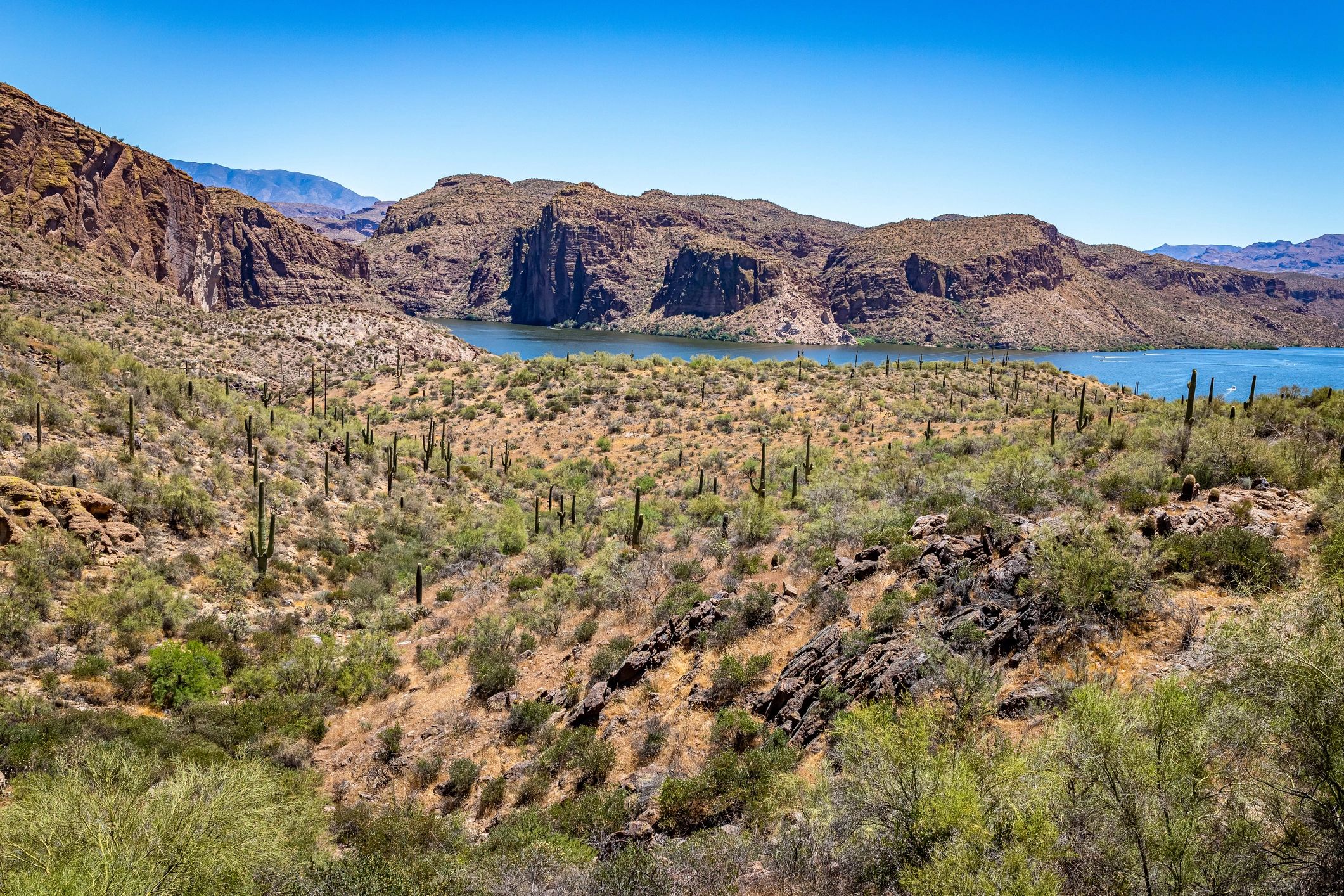
The approach to Roosevelt Lake on AZ-188 is one of the most dramatic road sections in Arizona — the road winds through canyon country with the lake appearing below in vivid blue against the desert brown. Roosevelt Dam itself is a National Historic Civil Engineering Landmark, and the bridge over the dam offers views of both the reservoir and the canyon below.
Above the lake, Tonto National Monument preserves two Salado cliff dwellings occupied approximately 700 years ago. The lower dwelling is accessible via a short paved trail and is one of the best-preserved prehistoric sites in the Southwest. This is a full-day commitment — plan for 8–10 hours including stops.
The Route
Starting point: Old Town Scottsdale (exact pickup address provided after Turo booking)
Scottsdale → Mesa (202 East or US-60)
Head east toward Mesa. About 20 miles, 25 minutes. Fuel up in Mesa — last reliable fuel before the lake.
Mesa → AZ-87 North (Beeline Highway)
Take AZ-87 north from Mesa. The road climbs out of the Valley and enters the Tonto National Forest. Pass Saguaro Lake and the Four Peaks Wilderness.
AZ-87 → AZ-188 (Roosevelt Lake Junction)
Turn left (west) on AZ-188 at the Roosevelt Lake junction. The road descends into the lake basin through canyon country. Roosevelt Lake comes into view after about 10 miles.
Roosevelt Dam and Bridge
Cross Roosevelt Dam on the historic bridge. The 1911 masonry dam is 357 feet tall and 723 feet long. Pull over on the bridge for views of both the lake and the canyon below.
Tonto National Monument
Located 2 miles east of the dam on AZ-188. The visitor center has exhibits on Salado culture. The lower cliff dwelling trail is 0.4 miles paved, 350-foot elevation gain. Open daily 8am–5pm. Entry fee required.
Return to Scottsdale
Return via AZ-188 to AZ-87 South, or loop through Globe on US-60 West for a different return route through Queen Creek Canyon.
Best Stops
Roosevelt Dam
The 1911 masonry dam is a National Historic Civil Engineering Landmark. The bridge over the dam is the best vantage point — views of the lake and the canyon below.
Tonto National Monument
Two Salado cliff dwellings occupied approximately 700 years ago. The lower dwelling is accessible via a short paved trail. One of the best-preserved prehistoric sites in the Southwest.
Roosevelt Lake Marina
Boat rentals, a small store, and lake views. Good lunch stop. The marina is on the south shore of the lake.
AZ-188 Canyon Approach
The descent into the Roosevelt Lake basin on AZ-188 is one of the most dramatic road sections in Arizona. Multiple pullouts for photography.
Globe (optional return)
The historic copper mining town of Globe is 30 miles south of Roosevelt Lake on US-60. The Besh-Ba-Gowah Archaeological Park preserves a Salado village from the same era as Tonto National Monument.
What You Need to Know
Fuel
Fill up in Mesa before heading north — use premium unleaded, 91 octane or higher. There is no fuel on AZ-87 between Mesa and Payson (60 miles). Roosevelt Lake area has limited fuel — check availability at the marina. Globe has fuel if returning via US-60.
Tonto National Monument
Entry fee is $10/vehicle. The lower cliff dwelling trail is 0.4 miles paved with 350-foot elevation gain. Open daily 8am–5pm. The upper dwelling requires a ranger-guided tour (advance reservation required).
Water and Food
Carry at least 2 liters of water per person. The Roosevelt Lake Marina has a small store. Globe has restaurants if returning via US-60.
Weather
Roosevelt Lake sits at about 2,100 feet — similar to Scottsdale in temperature. Summer heat is intense (100°F+). Spring and fall are ideal. Winter is generally fine but check for frost on mountain sections.
Cell Service
Limited cell service on AZ-87 north of Saguaro Lake and on AZ-188. Download offline maps before departure.
Road Conditions
AZ-87 and AZ-188 are well-maintained paved highways. No unpaved sections on the main route. Check az511.gov for current conditions.
Suggested Full-Day Itinerary
6:30 AM
Pick up Slingshot in Old Town Scottsdale
6:45 AM
Fuel up in Mesa, head north on AZ-87
8:00 AM
Saguaro Lake — brief stop for lake views
8:45 AM
Four Peaks viewpoints on AZ-87
9:30 AM
Turn west on AZ-188 — canyon descent to Roosevelt Lake
10:15 AM
Roosevelt Dam — walk the bridge, photography
11:00 AM
Tonto National Monument — lower cliff dwelling trail (1.5 hrs)
12:30 PM
Lunch at Roosevelt Lake Marina
2:00 PM
Begin return — AZ-188 to AZ-87 South, or loop via Globe/US-60
4:30 PM
Return Slingshot in Old Town Scottsdale
Book Your Roosevelt Lake Drive
Check real-time availability on Turo. Protection plans available at checkout. Old Town Scottsdale pickup.
Check Availability on Turo5.0★ · 47+ Five-Star Reviews