
Scottsdale → Fountain Hills via Shea Blvd
Fully paved · Slingshot-appropriate roads only
scottsdaleslingshots.com · /adventures/fountain-hills-saguaro-lake
Fountain Hills & Saguaro Lake Loop
Half day (4–5 hrs) · ~70 miles round trip from Old Town Scottsdale · 2.5–3 hrs with stops
Scottsdale → Fountain Hills → Saguaro Lake · ~70 miles
Fountain Hills & Saguaro Lake
Two of Arizona's most scenic destinations in one half-day loop. Desert mountains, a world-famous fountain, and turquoise water — all on paved roads from Old Town Scottsdale.
Check Availability on TuroDistance
~70 miles round trip from Old Town Scottsdale
Drive Time
2.5–3 hrs with stops
Rental Rec.
Half day (4–5 hrs)
Road Type
100% paved — no off-road
Difficulty
Easy — beginner friendly
Best Season
Oct–May (avoid summer midday heat)
Two Iconic Destinations, One Half-Day Drive
This loop combines two of the most rewarding destinations near Scottsdale into a single half-day drive. Head east on Shea Boulevard through the McDowell Mountains to Fountain Hills — home to one of the world's tallest fountains — then continue south on Saguaro Boulevard to the shores of Saguaro Lake.
Saguaro Lake sits inside Tonto National Forest, surrounded by red canyon walls and saguaro-studded hillsides. The Bush Highway approach is one of the most scenic paved roads in the Phoenix metro — wide open, lightly trafficked, and spectacular in a Slingshot.
The return leg brings you back through Mesa and Scottsdale on the 202 freeway or the scenic Usery Pass Road, depending on how much time you have. Either way, you're back in Old Town in under 30 minutes.
Route Directions
Starting point: Old Town Scottsdale, AZ
Old Town Scottsdale → Fountain Hills
East on Shea Blvd through McDowell Mountain Regional Park. ~30 miles, 35 min.
Fountain Hills → Saguaro Lake Marina
South on Saguaro Blvd to Bush Highway. ~20 miles, 25 min.
Saguaro Lake → Old Town Scottsdale
West on Bush Hwy to the 202 freeway. ~25 miles, 30 min.
Best Stops Along the Way
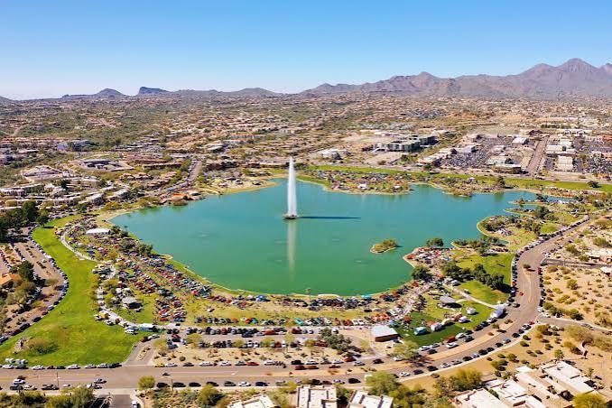
Fountain Hills Fountain
One of the world's tallest fountains — erupts on the hour. Great photo stop.
Saguaro Lake Marina
Desert reservoir with boat rentals, a restaurant, and canyon wall views.
McDowell Mountain Overlook
Pullout views of the McDowell Mountains and Scottsdale valley on the way out.
Bush Highway Corridor
One of the most scenic paved roads in the Phoenix metro — open desert canyon driving at its best.
What to Know Before You Go
Best time to go
Early morning on weekdays for the lightest traffic and coolest temperatures. The fountain runs on the hour — plan your Fountain Hills stop accordingly.
Gas and food
Fill up before leaving Old Town. Fountain Hills has several restaurants and a Starbucks. Saguaro Lake Marina has a snack bar and full restaurant.
No motorcycle license needed
Arizona classifies the Polaris Slingshot as an autocycle. A standard driver's license is all you need.
What to bring
Sunscreen, sunglasses, and a hat — the Slingshot is open-air. A light jacket for early morning departures in cooler months.
Sample Half-Day Itinerary
8:00 AM
Pick up your Slingshot in Old Town Scottsdale
8:45 AM
Arrive Fountain Hills — catch the fountain on the hour
9:30 AM
Continue south to Saguaro Lake Marina
10:00 AM
Explore the lake, grab breakfast at the marina
11:00 AM
Return to Old Town via Bush Highway and the 202
Ready to Drive This Route?
Book your Polaris Slingshot on Turo and hit the road. No motorcycle license required.
Check Availability on TuroBooked securely through Turo · 5.0★ rating · No motorcycle license required